Technical Assistance to Watershed Agencies in Morocco
The Morocco Economic Competitiveness Program (MEC) from USAID had several objectives associated with Morocco’s development. One of which was to provide technical assistance to Moroccan watershed basin agencies. Enviro Spatial was engaged working along with other project personnel to provide assistance through the application of GIS and database technologies.
Assistance for selected basin agencies mainly focused on their Contrat de Nappe (CdN) process. The CdN is a watershed management approach that unites stakeholders (water users managers) in an transparent effort to arrive at a consensus approach to water resource management. Key aspects of the assistance provided are listed below:
• Designed and developed a CdN Geo-database to integrate available pertinent water resource data (historical and current water use and water quality) from different sources into a single repository. This was done in an effort to show the temporal changes of the water resource and it uses to stakeholders.
• Prepared map and graphic outputs that present aquifer characteristics and tendencies from the CdN geodatabase.
• Analyzed satellite images and extracted irrigated areas for six time periods ~ 1970, 1980, 1990, 2000, 2005, 2010.
• Designed and developed a spatially enabled Water Use database that was used to manage water abstractions information.
• Designed and developed mobile spatially enabled data collection tools using ARCPAD for the field survey inventory of groundwater abstractions for wells and boreholes.
• Integrated field data and performed quality assurance data analysis for the collected water use data.
• Provided and presented several maps and graphic data analysis of the water use data.
• Provided technical support for hydrodynamic and geochemical modeling options.
• Presented options, and advantages and disadvantages of aquifer vulnerability and risk models
• Identified needs and developed the specifications for the CdN web portal which communicated CdN information and activities to concerned stakeholders.
• Designed and developed a spatially enabled water quality database for the two basin agencies. This included the database structure, coding and nomenclature identification and the creation of the physical database.
• Developed the data and created maps that presented land cover and threats to water resources and biodiversity for the two basin agencies.

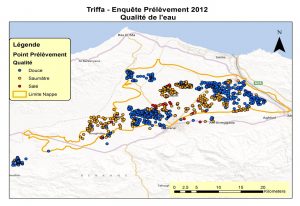
Salinity – Triffa
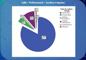
Triffa – Water Use by Ag Type
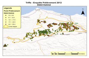
Triffa Water Use – Debit